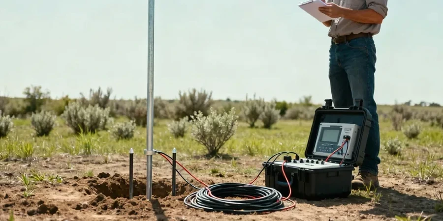
Around the Pittsburgh area, with its deeply incised valleys and slopes blanketed in colluvium over cyclic Pennsylvanian sedimentary rock, we often see surprises once excavation starts. You can hit an old mine entry, a perched water lens inside weathered shale, or a boulder train that wasn't on the drawings. That's where a resistivity survey becomes a practical tool before the backhoe ever arrives. Our crew runs vertical electrical soundings across the site and we interpret the layered resistivity structure based on local experience with the Conemaugh and Monongahela Groups. A Schlumberger array works well here when you need to look past the fill and into the natural strata, and it gives us a continuous profile without cutting a single borehole.
Electrical resistivity lets us map what lies between borings — essential in Pittsburgh's lensed colluvium and mined-out Allegheny Formation.
Scope of work in Pittsburgh
Demonstration video
Local geotechnical conditions in Pittsburgh
Pittsburgh's freeze-thaw cycles and abundant rainfall — averaging about 38 inches a year — keep the shallow soils saturated for long stretches, and that changes the resistivity baseline dramatically. A clay seam that reads 20 ohm-m in April might jump to 35 ohm-m after a dry August, and if you don't account for seasonal moisture swings, you can misidentify a wet clay lens as a contaminant plume or a void as a dry boulder. We schedule resistivity surveys with an eye on recent weather and always run a few calibration points against known borehole logs. In areas with abandoned mine works — and there are thousands of mapped and unmapped entries across Allegheny County — a resistivity low that dips and then pinches out is something we flag immediately. It's often the signature of a collapsed drift with saturated rubble, and missing it can mean differential settlement under a slab or a sudden opening during grading.
Our services
Every resistivity survey we run in Pittsburgh is scoped around the specific question the project needs answered — whether that's mapping bedrock depth, locating abandoned mine workings, or defining a contaminant plume boundary. The two service tiers below cover most situations.
1D Vertical Electrical Sounding (VES)
A single-station Schlumberger sounding that resolves layer resistivity and thickness beneath a point. We use it for foundation investigations where you need a quick, non-invasive check on depth to bedrock or the presence of a conductive clay layer. Data is inverted with a smoothness-constrained least-squares routine and cross-checked against any available boring logs.
2D Electrical Resistivity Tomography (ERT)
A multi-electrode profile — typically 56 or 112 electrodes — that builds a continuous cross-section of subsurface resistivity. This is the go-to method for slope stability studies along Pittsburgh's river bluffs, for detecting abandoned mine entries that trend across a site, and for delineating perched water zones in colluvial slopes. We process the data with solid inversion that handles the high resistivity contrasts between sandstone and shale.
Quick answers
What does a resistivity survey typically cost for a standard Pittsburgh residential or commercial lot?
For a typical lot in the Pittsburgh area, a single VES sounding or a short 2D profile runs between US$610 and US$1,190 depending on line length, number of electrodes, and terrain accessibility. We'll give you a firm number once we know the target depth and site layout.
How deep can resistivity testing see in the soils and rock around Pittsburgh?
With a Schlumberger array expanded to an AB/2 of 300 feet, we reliably resolve layers down to roughly 120 feet in the Pittsburgh area. Depth penetration depends on the local resistivity structure — conductive clay and saturated shale attenuate signal faster than dry sandstone, so we adjust the maximum spread accordingly.
Can resistivity distinguish between a water-filled mine void and a natural clay lens?
Both show up as low-resistivity anomalies, which is why interpretation matters. We look at the geometry: a clay lens in colluvium tends to be tabular and follows the slope, while a mine entry is often a discrete, dipping low that cuts across stratigraphy. We always calibrate against boring logs when they're available, and if the anomaly is critical, we recommend a targeted test pit or borehole to confirm.